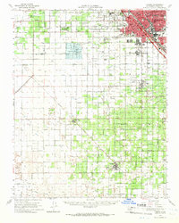
1963 Map of Fresno
USGS Topo · Published 1966About this map
The sprawling agricultural landscape of the San Joaquin Valley is anchored by the urban expansion of Fresno and several rural communities in the mid-1960s. A intricate network of irrigation channels, including the Houghton Canal, Central Canal, and Washington Colony Canal, demonstrates the highly engineered nature of this farming region. Significant transportation corridors like the Southern Pacific and the Atchison Topeka and Santa Fe Railway pass through Calwa and Easton, linking the valley's produce to distant markets.
Find a feature on this map
70 named features on this map. Tap any name to fly to it.
Don’t see what you’re looking for? This feature index may not catch every label — zoom into the map to look around manually.
Map Details
Editions of this 1963 Fresno Map
This is the sole edition of this map. No revisions or reprints were ever made.
Other maps of this area

1912 · Coalinga
USGS Topo · 1:125,000

1921 · Bullard
USGS Topo · 1:31,680

1923 · Kearney Park
USGS Topo · 1:31,680

1923 · Malaga
USGS Topo · 1:31,680

1923 · Herndon
USGS Topo · 1:31,680

1923 · Fresno
USGS Topo · 1:31,680

1923 · Clovis
USGS Topo · 1:31,680

1923 · Biola
USGS Topo · 1:31,680

1923 · Bullard
USGS Topo · 1:31,680

1924 · Riverdale
USGS Topo · 1:31,680