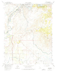
1964 Map of Friant
USGS Topo · Published 1975About this map
The San Joaquin River defines the landscape of this 1960s-era survey, where the massive Friant Dam holds back the waters of Millerton Lake. The settlement of Friant sits just below the dam, serving as a hub for water management and transit. This era highlights the sophisticated irrigation network supporting the Central Valley, specifically the Friant Kern Canal and the North Fork Canal. The Southern Pacific railroad line terminates near the river, signaling the importance of rail transport for both construction and agriculture in this foothills region. South of the dam, the terrain transitions into a more developed grid near Gordon, while the east is dominated by the elevations of Owens Mountain and the seasonal flows of Little Dry Creek. Geologists and local historians can trace the industrial footprint of the area through various mines and a Gravel Pit along the riverbanks.
Find a feature on this map
32 named features on this map. Tap any name to fly to it.
Don’t see what you’re looking for? This feature index may not catch every label — zoom into the map to look around manually.
Map Details
Editions of this 1964 Friant Map
3 editions found
Other maps of this area

1912 · Mariposa
USGS Topo · 1:125,000

1916 · Sulphur Springs
USGS Topo · 1:24,000

1919 · Sulphur Springs
USGS Topo · 1:31,680

1919 · Little Table Mountain
USGS Topo · 1:31,680

1921 · Bullard
USGS Topo · 1:31,680

1922 · Round Mountain
USGS Topo · 1:31,680

1922 · Lanes Bridge
USGS Topo · 1:31,680

1922 · Friant
USGS Topo · 1:31,680

1923 · Academy
USGS Topo · 1:31,680

1923 · Clovis
USGS Topo · 1:31,680