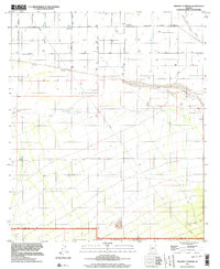
1996 Map of Friendly Corners
USGS Topo · Published 2003About this map
Friendly Corners sits at the nexus of an extensive desert irrigation network in Pinal County, where the infrastructure of the Greene Canal and Main Canal dominates the landscape. This 1990s-era survey reveals the complex water management required for agriculture and industry in the arid flats near the Santa Cruz River. The map captures the transition from the gridded agricultural roads like Sunshine Boulevard and Curtis Road to the more varied terrain of the Ironwood Forest National Monument in the south. Local water features such as Big Tank, Morris Tank, and Greene Reservoir illustrate the critical role of water storage for the surrounding wells and Substations. Further south, the map identifies exploratory sites including multiple Drill Holes, marking the intersection of resource extraction and protected federal lands at the Pinal and Pima County border.
Find a feature on this map
25 named features on this map. Tap any name to fly to it.
Don’t see what you’re looking for? This feature index may not catch every label — zoom into the map to look around manually.
Map Details
Editions of this 1996 Friendly Corners Map
This is the sole edition of this map. No revisions or reprints were ever made.
Other maps of this area

1934 · Tucson Mountains
USGS Topo · 1:125,000

1934 · Silver Bell
USGS Topo · 1:125,000

1934 · Newman Peak
USGS Topo · 1:125,000

1947 · Red Rock
USGS Topo · 1:62,500

1947 · Eloy
USGS Topo · 1:62,500

1948 · Eloy
USGS Topo · 1:62,500

1956 · Tucson
USGS Topo · 1:250,000

1958 · Tucson
USGS Topo · 1:250,000

1959 · Tucson
USGS Topo · 1:250,000

1959 · Vaca Hills
USGS Topo · 1:62,500