
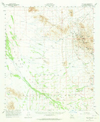
1959 Map of Vaca Hills
USGS Topo · Published 1961About this map
Industrial copper extraction dominates the eastern foothills of the West Silver Bell Mountains on this mid-century survey. The landscape is marked by the extensive operations of the Silver Bell Mine, including the Oxide Pit, El Tiro Pit, and the Union Hill Pit. Deep subterranean workings are evidenced by the Daisy Shaft and Mammoth Incline, while the human history of the mining camp is preserved at the Silver Bell (Site) and the nearby Silver Bell Cem. An Old Railroad Grade traces the former path of ore transport leading away from the mining complex.
Find a feature on this map
44 named features on this map. Tap any name to fly to it.
Don’t see what you’re looking for? This feature index may not catch every label — zoom into the map to look around manually.
Map Details
Editions of this 1959 Vaca Hills Map
2 editions found
Other maps of this area

1934 · Tucson Mountains
USGS Topo · 1:125,000

1934 · Silver Bell
USGS Topo · 1:125,000

1934 · Newman Peak
USGS Topo · 1:125,000

1937 · Comobabi
USGS Topo · 1:48,000

1938 · San Vicente
USGS Topo · 1:62,500

1941 · San Vicente
USGS Topo · 1:62,500

1941 · Cocoraque Butte
USGS Topo · 1:62,500

1942 · Silver Reef Mountains
USGS Topo · 1:62,500

1942 · San Vicente
USGS Topo · 1:62,500

1942 · Comobabi
USGS Topo · 1:62,500
Featured Places
- Silver Bell, AZ
- Quinlin, Schuk Toak District
- Schuk Toak District, AZ
- Skoksonak, Schuk Toak District
- Queens Well, Schuk Toak District