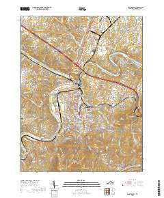
2019 Map of Front Royal
USGS Topo · Published 2019About this map
Front Royal serves as the focal point of this Warren County survey, situated where the North Fork Shenandoah River and South Fork Shenandoah River converge. The town's layout reflects its role as a regional hub, featuring the Warren County Courthouse and neighborhoods such as Viscose City, Woodland Park, and Riverside. To the south, the terrain rises sharply toward Dickey Ridge and the northern reaches of Shenandoah National Park, where the Appalachian National Scenic Trail winds through the high ground of Valley of Retreat. Local genealogy is well-represented through several burial sites, including Prospect Hill Cem and the Ramey Graveyard near Dungadin Heights. The map also captures the educational presence of Christendom College near the Shenandoah River and critical infrastructure like the Front Royal-Warren County Airport.
Find a feature on this map
237 named features on this map. Tap any name to fly to it.
Don’t see what you’re looking for? This feature index may not catch every label — zoom into the map to look around manually.
Map Details
Editions of this 2019 Front Royal Map
This is the sole edition of this map. No revisions or reprints were ever made.
Other maps of this area

1893 · Luray
USGS Topo · 1:125,000

1894 · Winchester
USGS Topo · 1:125,000

1905 · Luray
USGS Topo · 1:125,000

1923 · Middletown
USGS Topo · 1:62,500

1937 · Middletown
USGS Topo · 1:48,000

1938 · Winchester
USGS Topo · 1:48,000

1939 · Front Royal
USGS Topo · 1:48,000

1942 · Winchester
USGS Topo · 1:62,500

1943 · Middletown
USGS Topo · 1:62,500

1944 · Front Royal
USGS Topo · 1:62,500