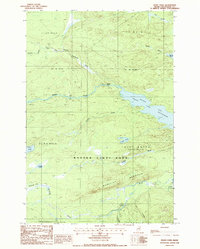
1988 Map of Frost Pond
USGS Topo · Published 1988About this map
Baxter State Park encompasses much of this Maine wilderness, where the East Branch Penobscot River flows through a landscape defined by significant water bodies and topographic rises. The map documents the northern expanse of the park during the late 1980s, highlighting the interconnected waters of Grand Lake, Second Lake, and Lake Matagamon. Historical transit is marked by the Indian Carry trail along Webster Brook, a traditional portage route through the woods. To the south, Wadleigh Mountain stands as a prominent landmark above Wadleigh Bog and Trout Brook. This survey provides a record of recreational and conservation infrastructure in the North Woods, including the Trout Brook Crossing and various campsites that supported the logging-turned-recreational economy of the region.
Find a feature on this map
33 named features on this map. Tap any name to fly to it.
Don’t see what you’re looking for? This feature index may not catch every label — zoom into the map to look around manually.
Map Details
Editions of this 1988 Frost Pond Map
This is the sole edition of this map. No revisions or reprints were ever made.
Other maps of this area

1953 · Telos Lake
USGS Topo · 1:62,500

1954 · Spider Lake
USGS Topo · 1:62,500

1954 · Millinocket Lake
USGS Topo · 1:62,500

1954 · Presque Isle
USGS Topo · 1:250,000

1955 · Traveler Mountain
USGS Topo · 1:62,500

1957 · Telos Lake
USGS Topo · 1:62,500

1958 · Presque Isle
USGS Topo · 1:250,000

1960 · Presque Isle
USGS Topo · 1:250,000

1961 · Spider Lake
USGS Topo · 1:62,500
1975 · The Traveler
USGS Topo · 1:24,000