
1954 Map of Spider Lake
USGS Topo · Published 1955About this map
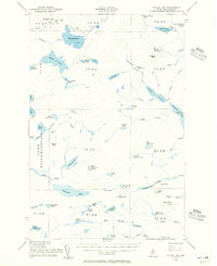
Pleasant Lake and the labyrinthine waterways of the Piscataquis wilderness define this mid-century survey of the North Maine Woods. The landscape is characterized by a dense network of glacial ponds and interconnecting streams, including Spider Lake, Chase Lake, and the sprawling Munsungun Lake. This era shows a remote interior accessed primarily by a few trails and a lone Jeep Trail, illustrating the region's character as a timber and sporting territory before modern development. Notable elevations such as Soper Mountain and Pleasant Mtn rise above the wetlands. A lone Lookout Tower sits atop Beetle Mtn, signaling the area's ongoing management for fire protection. Small features like Sewall Deadwater on Munsungun Brook provide specific location data for those researching the historical hydrology and logging routes of the upper Penobscot watershed.
Find a feature on this map
75 named features on this map. Tap any name to fly to it.
Don’t see what you’re looking for? This feature index may not catch every label — zoom into the map to look around manually.
Map Details
Editions of this 1954 Spider Lake Map
2 editions found
Other maps of this area

1931 · Mooseleuk Lake
USGS Topo · 1:48,000

1932 · Umsaskis Lake
USGS Topo · 1:48,000

1932 · Musquacook Lakes
USGS Topo · 1:48,000

1935 · Umsaskis Lake
USGS Topo · 1:62,500

1935 · Musquacook Lakes
USGS Topo · 1:62,500

1935 · Mooseleuk Lake
USGS Topo · 1:62,500

1953 · Telos Lake
USGS Topo · 1:62,500

1954 · Chesuncook
USGS Topo · 1:62,500

1954 · Churchill Lake
USGS Topo · 1:62,500

1954 · Millinocket Lake
USGS Topo · 1:62,500