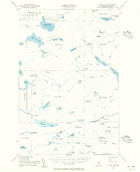
1954 Map of Spider Lake
USGS Topo · Published 1956About this map
Spider Lake and the complex drainage of the North Maine Woods characterize this mid-century topographic study. The landscape is defined by a dense network of interconnected waterways, including Pleasant Lake, Echo Lake, and the winding Sewall Deadwater. Surveyed just after the war, the map reveals a remote territory organized into survey townships such as T 9 R 11 and T 8 R 11, with transportation limited largely to a Jeep Trail and numerous footpaths marked simply as Trail.
Find a feature on this map
82 named features on this map. Tap any name to fly to it.
Don’t see what you’re looking for? This feature index may not catch every label — zoom into the map to look around manually.
Map Details
Editions of this 1954 Spider Lake Map
2 editions found
Other maps of this area

1931 · Mooseleuk Lake
USGS Topo · 1:48,000

1932 · Umsaskis Lake
USGS Topo · 1:48,000

1932 · Musquacook Lakes
USGS Topo · 1:48,000

1935 · Umsaskis Lake
USGS Topo · 1:62,500

1935 · Musquacook Lakes
USGS Topo · 1:62,500

1935 · Mooseleuk Lake
USGS Topo · 1:62,500

1953 · Telos Lake
USGS Topo · 1:62,500

1954 · Chesuncook
USGS Topo · 1:62,500

1954 · Spider Lake
USGS Topo · 1:62,500

1954 · Churchill Lake
USGS Topo · 1:62,500