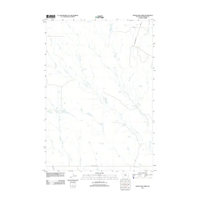
2012 Map of Frozen Man Creek
USGS Topo · Published 2012About this map
Frozen Man Cr and its many tributaries define the hydrology of this rural Meade County landscape, where water drainage patterns dictate the placement of ranch roads and township boundaries. The map reveals an intricate network of intermittent streams, including Plum Cr, Trail Cr, and Spring Cr, which converge to form a complex watershed system. Human presence is marked by a sparse but deliberate grid of local travel routes such as Eagle Township Rd and the significant Sulphur Cutoff Rd at the southern margin. This survey captures the essential character of the Great Plains, where large-scale ranching and land management are organized around the availability of water at Whistle Cr and Lottie Cr.
Find a feature on this map
13 named features on this map. Tap any name to fly to it.
Don’t see what you’re looking for? This feature index may not catch every label — zoom into the map to look around manually.
Map Details
Editions of this 2012 Frozen Man Creek Map
This is the sole edition of this map. No revisions or reprints were ever made.
Other maps of this area

1951 · Cedar Canyon
USGS Topo · 1:24,000

1953 · Rapid City
USGS Topo · 1:250,000

1954 · Lemmon
USGS Topo · 1:250,000

1957 · Lemmon
USGS Topo · 1:250,000

1957 · Rapid City
USGS Topo · 1:250,000

1973 · Frozen Man Creek
USGS Topo · 1:24,000

1977 · Table Top Butte
USGS Topo · 1:24,000
1978 · Camp Creek
USGS Topo · 1:24,000

1978 · Bull Run Creek
USGS Topo · 1:24,000

1980 · Beverly Creek
USGS Topo · 1:25,000