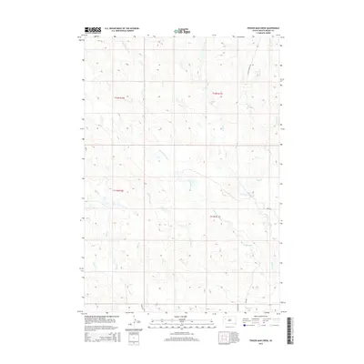
2015 Map of Frozen Man Creek
USGS Topo · Published 2015About this map
Frozen Man Creek winds through the rolling grasslands of Meade County, defining a drainage system that includes Plum Cr, Trail Cr, and Whistle Cr. This 2015 survey illustrates a sparsely populated ranching landscape where historical transportation routes like Old 212 and Fairpoint Rd intersect with the section lines of the Public Land Survey System. The map documents the intricate network of seasonal waterways, including Spring Cr and Eagle Cr, which are vital to the agricultural character of the region. Local access is maintained via rural arteries such as Eagle Township Rd and Kentucky Pl, while the topography is marked by subtle elevation changes across townships like T12N R10E and T11N R11E. This topographical record is essential for understanding the hydrology and land division of Western South Dakota in the early 21st century.
Find a feature on this map
18 named features on this map. Tap any name to fly to it.
Don’t see what you’re looking for? This feature index may not catch every label — zoom into the map to look around manually.
Map Details
Editions of this 2015 Frozen Man Creek Map
This is the sole edition of this map. No revisions or reprints were ever made.
Other maps of this area

1951 · Cedar Canyon
USGS Topo · 1:24,000

1953 · Rapid City
USGS Topo · 1:250,000

1954 · Lemmon
USGS Topo · 1:250,000

1957 · Lemmon
USGS Topo · 1:250,000

1957 · Rapid City
USGS Topo · 1:250,000

1973 · Frozen Man Creek
USGS Topo · 1:24,000

1977 · Table Top Butte
USGS Topo · 1:24,000
1978 · Camp Creek
USGS Topo · 1:24,000

1978 · Bull Run Creek
USGS Topo · 1:24,000

1980 · Beverly Creek
USGS Topo · 1:25,000