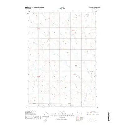
2017 Map of Frozen Man Creek
USGS Topo · Published 2017About this map
Mudd Butte stands as a prominent landmark in this portion of Meade County, overlooking the high plains drainage network. The landscape is defined by the convergence of several ephemeral watercourses, including Frozen Man Creek, Spring Cr, and Whistle Cr, which carve shallow paths through the prairie. In the northwest corner, the Mudd Butte Cem provides a specific point of interest for genealogists tracing local families in this sparsely populated region. The map documents a network of local roads such as Eagle Township Rd and Co Hwy MC-28, which follow the section lines of the Public Land Survey System across Township 11 and 12 North. This modern survey reflects the enduring cattle-ranching character of the territory, where water sources like Plum Cr and Lottie Cr remain central to the geography.
Find a feature on this map
19 named features on this map. Tap any name to fly to it.
Don’t see what you’re looking for? This feature index may not catch every label — zoom into the map to look around manually.
Map Details
Editions of this 2017 Frozen Man Creek Map
This is the sole edition of this map. No revisions or reprints were ever made.
Other maps of this area

1951 · Cedar Canyon
USGS Topo · 1:24,000

1953 · Rapid City
USGS Topo · 1:250,000

1954 · Lemmon
USGS Topo · 1:250,000

1957 · Lemmon
USGS Topo · 1:250,000

1957 · Rapid City
USGS Topo · 1:250,000

1973 · Frozen Man Creek
USGS Topo · 1:24,000

1977 · Table Top Butte
USGS Topo · 1:24,000
1978 · Camp Creek
USGS Topo · 1:24,000

1978 · Bull Run Creek
USGS Topo · 1:24,000

1980 · Beverly Creek
USGS Topo · 1:25,000