
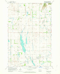
1967 Map of Ft. Ransom
USGS Topo · Published 1969About this map
Sheyenne River meanders through a deeply incised valley in this late-1960s survey of southeastern North Dakota. The landscape is defined by the contrast between the flat upland agricultural fields and the wooded, winding river corridor. Fort Ransom serves as the primary settlement, positioned near the historic Site of old Ft Ransom. The area is notably rich in indigenous and early frontier landmarks, including several clusters of Indian Mounds, the Writing Rock, and prominent terrain features such as Bears Den Hillock and The Pyramid.
Find a feature on this map
27 named features on this map. Tap any name to fly to it.
Don’t see what you’re looking for? This feature index may not catch every label — zoom into the map to look around manually.
Map Details
Editions of this 1967 Ft. Ransom Map
This is the sole edition of this map. No revisions or reprints were ever made.
Other maps of this area

1895 · Lamoure
USGS Topo · 1:125,000

1897 · Tower
USGS Topo · 1:125,000

1897 · Eckelson
USGS Topo · 1:125,000

1918 · La Moure
USGS Topo · 1:125,000

1953 · Jamestown
USGS Topo · 1:250,000

1953 · Fargo
USGS Topo · 1:250,000

1956 · Fargo
USGS Topo · 1:250,000

1956 · Jamestown
USGS Topo · 1:250,000
1962 · Englevale
USGS Topo · 1:24,000

1962 · Elliott
USGS Topo · 1:24,000
Featured Places
- Fort Ransom, ND
- Fort Ransom Township, ND
- Springer Township, ND
- Preston Township, ND
- Northland Township, ND