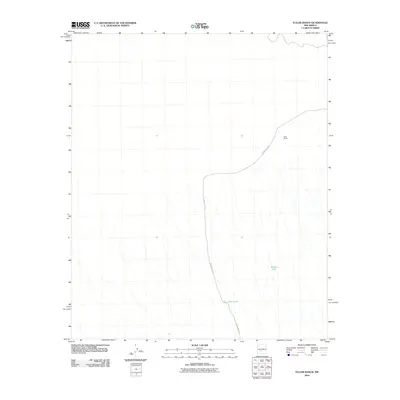
2010 Map of Fuller Ranch
USGS Topo · Published 2010About this map
Fuller Ranch occupies a prominent position in this arid landscape of Socorro County, New Mexico. The geography is defined by a series of parallel drainage patterns that flow southeast, collected at strategic points like Middle Tank and AAA Tank. These water management features are critical for life in this dry rangeland, illustrating how the natural topography dictates the placement of ranching infrastructure. County Rd-A031 serves as the primary artery through this high-desert environment, winding through the drainages to connect the ranch with the surrounding region. The layout of the road and the distribution of tanks across the terrain provide a clear picture of rural New Mexico land use and the essential nature of water access in the high desert at the beginning of the 21st century.
Find a feature on this map
4 named features on this map. Tap any name to fly to it.
Don’t see what you’re looking for? This feature index may not catch every label — zoom into the map to look around manually.
Map Details
Editions of this 2010 Fuller Ranch Map
This is the sole edition of this map. No revisions or reprints were ever made.
Other maps of this area

1916 · Salinas Peak
USGS Topo · 1:125,000

1948 · Granjean Well
USGS Topo · 1:62,500

1948 · Val Verde
USGS Topo · 1:62,500

1948 · Malpais Well
USGS Topo · 1:62,500

1948 · Salinas Peak
USGS Topo · 1:62,500

1954 · Tularosa
USGS Topo · 1:250,000

1958 · Tularosa
USGS Topo · 1:250,000

1981 · Big Gyp Mountain
USGS Topo · 1:24,000
1981 · Fence Canyon
USGS Topo · 1:24,000
1981 · Fairview Well
USGS Topo · 1:24,000