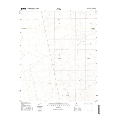
2017 Map of Fuller Ranch
USGS Topo · Published 2017About this map
Fuller Ranch stands as the primary named point of human activity in this arid New Mexico landscape, situated at the boundary between Socorro and Sierra counties. The 2017 terrain is defined by a series of north-south township and range lines, including t10s r1e, which organize a territory characterized by subtle elevation changes and vital water-collection points like AAA Tank and Middle Tank. Transportation through this high-desert environment is facilitated by the intersection of Fuller Rd and Co Rd Ao31, which serve as the lifelines for the sparse settlement and agricultural infrastructure. The map illustrates a contemporary view of the land-management patterns in this portion of the Rio Grande valley watershed, where the Socorro Co Sierra Co line marks a significant geopolitical transition point.
Find a feature on this map
12 named features on this map. Tap any name to fly to it.
Don’t see what you’re looking for? This feature index may not catch every label — zoom into the map to look around manually.
Map Details
Editions of this 2017 Fuller Ranch Map
This is the sole edition of this map. No revisions or reprints were ever made.
Other maps of this area

1916 · Salinas Peak
USGS Topo · 1:125,000

1948 · Granjean Well
USGS Topo · 1:62,500

1948 · Val Verde
USGS Topo · 1:62,500

1948 · Malpais Well
USGS Topo · 1:62,500

1948 · Salinas Peak
USGS Topo · 1:62,500

1954 · Tularosa
USGS Topo · 1:250,000

1958 · Tularosa
USGS Topo · 1:250,000

1981 · Big Gyp Mountain
USGS Topo · 1:24,000
1981 · Fence Canyon
USGS Topo · 1:24,000
1981 · Fairview Well
USGS Topo · 1:24,000