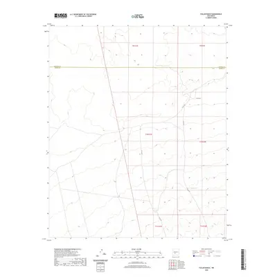
2020 Map of Fuller Ranch
USGS Topo · Published 2020About this map
Fuller Ranch occupies a central position in this high-desert landscape, where the border of Socorro County and Sierra County meets. This 2020 survey highlights the sparse but essential infrastructure of the New Mexico interior, centered on livestock and water management. Transportation is defined by the intersection of Fuller Rd and Co Rd A031, which serve as the primary conduits through the basin. Strategic water sources such as Middle Tank and Maa Tank are critical markers on the map, indicating the continued reliance on these catchments for ranching operations in a dry climate. The grid-like division of townships and ranges overlaying the terrain provides a clear view of land management and property boundaries in this open range country.
Find a feature on this map
6 named features on this map. Tap any name to fly to it.
Don’t see what you’re looking for? This feature index may not catch every label — zoom into the map to look around manually.
Map Details
Editions of this 2020 Fuller Ranch Map
This is the sole edition of this map. No revisions or reprints were ever made.
Other maps of this area

1916 · Salinas Peak
USGS Topo · 1:125,000

1948 · Granjean Well
USGS Topo · 1:62,500

1948 · Val Verde
USGS Topo · 1:62,500

1948 · Malpais Well
USGS Topo · 1:62,500

1948 · Salinas Peak
USGS Topo · 1:62,500

1954 · Tularosa
USGS Topo · 1:250,000

1958 · Tularosa
USGS Topo · 1:250,000

1981 · Big Gyp Mountain
USGS Topo · 1:24,000
1981 · Fence Canyon
USGS Topo · 1:24,000
1981 · Fairview Well
USGS Topo · 1:24,000