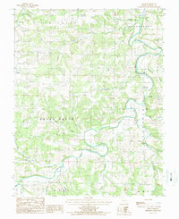
1987 Map of Fuson
USGS Topo · Published 1987About this map
The Gasconade River meanders deeply through this portion of Wright County, defining a landscape of hollows and tributary branches in the late 1980s. Local history is anchored by the small settlement of Fuson and the presence of historic water-powered industry sites like Grimes Mill and Latham Mill, which sit along the river and its feeders. Several unmarked Cem locations suggest family burial plots common in the rural Ozark highlands. The terrain is marked by significant drainages including Brush Creek, Elk Creek, and Indian Creek, while the Buzzard Bluff State Access provides a dedicated point of contact with the river. The map also records numerous local named hollows such as Wildcat Hollow, Garner Hollow, and Young Hollow, which reveal the traditional naming conventions of the region's early residents and the intricate drainage network of the Hart and Wood townships.
Find a feature on this map
30 named features on this map. Tap any name to fly to it.
Don’t see what you’re looking for? This feature index may not catch every label — zoom into the map to look around manually.
Map Details
Editions of this 1987 Fuson Map
This is the sole edition of this map. No revisions or reprints were ever made.
Other maps of this area

1931 · Manes
USGS Topo · 1:48,000

1941 · Manes
USGS Topo · 1:62,500

1943 · Manes
USGS Topo · 1:62,500

1951 · Mountain Grove North
USGS Topo · 1:24,000

1951 · Owens
USGS Topo · 1:24,000

1951 · Mansfield NE
USGS Topo · 1:24,000

1951 · Mountain Grove
USGS Topo · 1:62,500

1954 · Springfield
USGS Topo · 1:250,000
1956 · Hartville
USGS Topo · 1:24,000
1956 · Grovespring
USGS Topo · 1:24,000