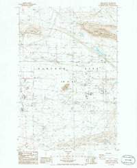
1986 Map of Gable Butte
USGS Topo · Published 1986About this map
The Hanford Site (DOE) dominates this mid-1980s landscape, illustrating the heavy industrial and utility infrastructure of the Department of Energy’s operations in Benton County. The map reveals an intricate network of transmission lines and numerous Radio Towers supporting the site's complex communication needs. Significant geological elevations like Gable Mountain and Gable Butte rise above the terrain, which is otherwise marked by utilitarian features such as a Substation, Fire Station, and various Borrow Pits. Historically interesting clusters like Helen, Susie, Ethel, Pearl, and Willa suggest localized named points within the security-controlled zone. The presence of a Siphon and multiple gravel pits underscores the active land management and resource extraction required for the facility’s maintenance and development during this era of nuclear research and production.
Find a feature on this map
20 named features on this map. Tap any name to fly to it.
Don’t see what you’re looking for? This feature index may not catch every label — zoom into the map to look around manually.
Map Details
Editions of this 1986 Gable Butte Map
This is the sole edition of this map. No revisions or reprints were ever made.
Other maps of this area

1915 · Prosser
USGS Topo · 1:125,000

1916 · Coyote Rapids
USGS Topo · 1:62,500

1917 · Pasco
USGS Topo · 1:125,000

1917 · Prosser
USGS Topo · 1:125,000

1924 · Hanford
USGS Topo · 1:62,500

1951 · Richland
USGS Topo · 1:62,500

1951 · Hanford
USGS Topo · 1:62,500

1951 · Corral Canyon
USGS Topo · 1:62,500

1951 · Coyote Rapids
USGS Topo · 1:62,500

1953 · Walla Walla
USGS Topo · 1:250,000