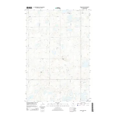
2014 Map of Gackle South
USGS Topo · Published 2014About this map
Gackle sits at the northeastern corner of this Logan County landscape, serving as a hub for the surrounding agricultural prairie. The terrain is characterized by a dense concentration of small wetlands and depressions typical of the Missouri Coteau, punctuated by distinctive landmarks like Buffalo Hill and Cactus Point. The road network follows the section line grid, including several routes like Neu Dorf Rd and New Dorf Rd that suggest the enduring German-Russian heritage of the region's settlers. Genealogy and local history researchers will find the Neudorf Cem in the northwest and Saari Cem in the southeast, marking the locations of earlier community focal points. Aviation infrastructure is present at the Gackle Municipal Airport, while the southern reaches of the quadrangle are dominated by water features such as School Lake.
Find a feature on this map
26 named features on this map. Tap any name to fly to it.
Don’t see what you’re looking for? This feature index may not catch every label — zoom into the map to look around manually.
Map Details
Editions of this 2014 Gackle South Map
This is the sole edition of this map. No revisions or reprints were ever made.
Other maps of this area

1953 · Jamestown
USGS Topo · 1:250,000

1956 · Jamestown
USGS Topo · 1:250,000

1982 · Fredonia NW
USGS Topo · 1:24,000

1982 · Lehr NE
USGS Topo · 1:24,000

1982 · Fredonia NE
USGS Topo · 1:24,000

1983 · Alfred
USGS Topo · 1:24,000

1983 · Streeter
USGS Topo · 1:24,000

1983 · Gackle North
USGS Topo · 1:24,000

1983 · Streeter SE
USGS Topo · 1:24,000
1983 · Gackle South
USGS Topo · 1:24,000