
1972 Map of Gainestown
USGS Topo · Published 1975About this map
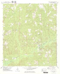
Gainestown sits along the northern bank of a deep bend in the Alabama River, serving as a focal point for this rural landscape in the early 1970s. The map documents a river-dependent geography defined by critical river access points such as Gainestown Landing and Eureka Landing. A notable historical marker, the Old Indian Treaty Bdy, cuts across the northwestern corner of the quadrangle, reflecting older territorial divisions that preceded the modern county lines of Clarke and Monroe counties. The settlement pattern is sparse, with small communities like Barlow Bend and Grove Hill connected by winding creeks like Sizemore Creek and Nixon Creek. Local social centers are marked by numerous churches and burial sites, including Rogers Temple, Antioch Ch, and the Good Hope Ch Cem, which remain vital for genealogical research in this part of southwest Alabama.
Find a feature on this map
23 named features on this map. Tap any name to fly to it.
Don’t see what you’re looking for? This feature index may not catch every label — zoom into the map to look around manually.
Map Details
Editions of this 1972 Gainestown Map
This is the sole edition of this map. No revisions or reprints were ever made.
Other maps of this area

1943 · Choctaw Bluff
USGS Topo · 1:62,500

1946 · Choctaw Bluff
USGS Topo · 1:62,500

1953 · Andalusia
USGS Topo · 1:250,000

1957 · Andalusia
USGS Topo · 1:250,000

1972 · Chrysler
USGS Topo · 1:24,000

1972 · Uriah West
USGS Topo · 1:24,000

1972 · Flynns Lake
USGS Topo · 1:24,000

1972 · Claiborne
USGS Topo · 1:24,000

1972 · Suggsville
USGS Topo · 1:24,000
1978 · Walker Springs
USGS Topo · 1:24,000