
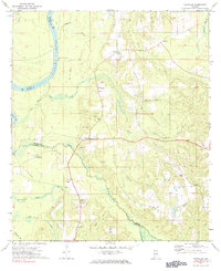
1972 Map of Chrysler
USGS Topo · Published 1974About this map
Alabama River bottomlands define the western edge of this Monroe County landscape, where the river winds past Mt Pleasant Landing and creates a complex network of creeks and bayous. The settlement of Chrysler sits at a junction of roads and an Old RR Grade that traces the movement of timber and goods through the region during the early-to-mid 20th century. Local life is anchored by community landmarks such as Mamies Chapel, Eliska Ch, and Mineola Ch, alongside numerous small cemeteries that offer significant value for genealogical research.
Find a feature on this map
36 named features on this map. Tap any name to fly to it.
Don’t see what you’re looking for? This feature index may not catch every label — zoom into the map to look around manually.
Map Details
Editions of this 1972 Chrysler Map
2 editions found
Other maps of this area

1942 · Perdido
USGS Topo · 1:62,500

1943 · Choctaw Bluff
USGS Topo · 1:62,500

1943 · Tensaw
USGS Topo · 1:62,500

1944 · Tensaw
USGS Topo · 1:62,500

1944 · Perdido
USGS Topo · 1:62,500

1946 · Choctaw Bluff
USGS Topo · 1:62,500

1953 · Andalusia
USGS Topo · 1:250,000

1957 · Andalusia
USGS Topo · 1:250,000

1972 · Uriah West
USGS Topo · 1:24,000

1972 · Flynns Lake
USGS Topo · 1:24,000