
Loading...
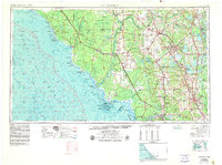
Loading map...1958 Map of Gainesville
USGS Topo · Published 1958About this map
Gainesville serves as the central hub of this North Central Florida landscape, where the regional economy in the mid-1950s was defined by a dense network of railroads and a complex aquatic geography. The Atlantic Coast Line and Seaboard Air Line intersect at key inland settlements like Newberry and High Springs, while the Georgia Southern and Florida line reaches toward the eastern lakes.
Find a feature on this map
88 named features on this map. Tap any name to fly to it.
Don’t see what you’re looking for? This feature index may not catch every label — zoom into the map to look around manually.
Map Details
Date Portrayed1958
Date Published1958
PublisherU.S. Geological Survey
Map TypeTopographic
Scale1:250000
Physical Dimensions34.27 x 22.1 inches
Editions of this 1958 Gainesville Map
This is the sole edition of this map. No revisions or reprints were ever made.
Historical Maps of Carlton Arms Through Time
4 maps found

Featured Locations
Source Details
SourceU.S. Geological Survey
CopyrightPublic Domain