1981 Map of Gainesville
USGS Topo · Published 1982About this map
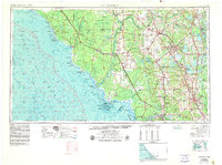
Gainesville serves as the central hub for this North Central Florida landscape in the early 1980s, anchored by the University of Florida and Gainesville Municipal Airport. The map highlights a region defined by its expansive water systems and conservation lands, from the Santa Fe River and Suwannee River in the west to the dense cluster of lakes including Kingsley Lake and Santa Fe Lake in the east. Large-scale land management is evident through the Camp Blanding Military Reservation and significant preserves like Paynes Prairie State Preserve.
Find a feature on this map
138 named features on this map. Tap any name to fly to it.
Don’t see what you’re looking for? This feature index may not catch every label — zoom into the map to look around manually.
Map Details
Editions of this 1981 Gainesville Map
2 editions found

Historical Maps of Gainesville Through Time
4 maps found