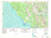
1954 Map of Gainesville
USGS Topo · Published 1980About this map
Gainesville serves as the inland anchor for this mid-century look at North Central Florida, a region defined by its diverse wetlands and slow-moving rivers. The map illustrates the hydrological connection between the interior and the Gulf of Mexico, as the Suwannee River and Steinhatchee River wind through the extensive Mallory Swamp toward Suwannee Sound. Along the coast, intricate features like the Pepperfish Keys and Tater Island are charted alongside the Cedar Keys Wilderness and NWR.
Find a feature on this map
184 named features on this map. Tap any name to fly to it.
Don’t see what you’re looking for? This feature index may not catch every label — zoom into the map to look around manually.
Map Details
Editions of this 1954 Gainesville Map
3 editions found

Other maps of this area

1890 · Arredondo
USGS Topo · 1:62,500

1892 · Dunnellon
USGS Topo · 1:62,500

1892 · Arredondo
USGS Topo · 1:62,500

1893 · Panasoffkee
USGS Topo · 1:62,500

1893 · Citra
USGS Topo · 1:62,500

1894 · Dunnellon
USGS Topo · 1:62,500

1894 · Arredondo
USGS Topo · 1:62,500

1895 · Williston
USGS Topo · 1:62,500

1895 · Tsala Apopka
USGS Topo · 1:62,500

1895 · Citra
USGS Topo · 1:62,500