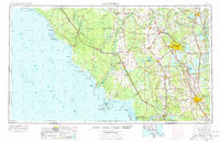
1954 Map of Gainesville
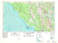
USGS Topo · Published 1977About this map
The Suwannee River carves a winding path through the heart of North Central Florida, defining the boundaries of Dixie, Levy, and Gilchrist counties as it flows toward the Gulf of Mexico. This mid-century landscape is dominated by the regional hubs of Gainesville and Ocala, connected by a network of primary roads including U S 441 and U S 301. Along the coast, the intricate shoreline reveals the Cedar Keys and the Cedar Keys Wilderness and NWR, while inland, the Seaboard Coast Line railroad links agricultural and timber towns like Williston, Chiefland, and Starke. Notable conservation areas such as Manatee Springs State Park and O'leno State Park protect the region's unique spring and river systems. To the east, the large water bodies of Orange Lake, Lochloosa Lake, and Newnans Lake punctuate the landscape, serving as historical landmarks for the small settlements of Micanopy and Hawthorne.
Find a feature on this map
82 named features on this map. Tap any name to fly to it.
Don’t see what you’re looking for? This feature index may not catch every label — zoom into the map to look around manually.
Map Details
Editions of this 1954 Gainesville Map
3 editions found

Other maps of this area

1890 · Arredondo
USGS Topo · 1:62,500

1892 · Dunnellon
USGS Topo · 1:62,500

1892 · Arredondo
USGS Topo · 1:62,500

1893 · Panasoffkee
USGS Topo · 1:62,500

1893 · Citra
USGS Topo · 1:62,500

1894 · Dunnellon
USGS Topo · 1:62,500

1894 · Arredondo
USGS Topo · 1:62,500

1895 · Williston
USGS Topo · 1:62,500

1895 · Tsala Apopka
USGS Topo · 1:62,500

1895 · Citra
USGS Topo · 1:62,500