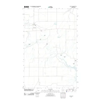
2011 Map of Galata
USGS Topo · Published 2011About this map
Galata serves as the primary hub in this portion of Toole County, a landscape defined by the drainage systems of Willow Creek and the West Fork Willow Creek. The settlement is closely tied to its transit roots, featuring the Galata Post Office and the Galata Motel and RV Campground. The surrounding prairie is etched with numerous named coulees, such as Clift Coulee and Edmister Coulee, reflecting a terrain shaped by seasonal water runoff. Significant water management is evident through the presence of the Zelenka Dam, Gillespie Reservoir, and the northern reaches of Lake Elwell. To the south, the historical Bootlegger Trl cuts across the plains, offering a window into the regional pathfinding of the past. Local genealogy is anchored at the Galata Cemetery, while the northern boundary features Lothair Spring, emphasizing the vital role of water sources in this high plains environment.
Find a feature on this map
26 named features on this map. Tap any name to fly to it.
Don’t see what you’re looking for? This feature index may not catch every label — zoom into the map to look around manually.
Map Details
Editions of this 2011 Galata Map
This is the sole edition of this map. No revisions or reprints were ever made.
Other maps of this area

1954 · Shelby
USGS Topo · 1:250,000

1958 · Shelby
USGS Topo · 1:250,000

1962 · North Lothair School
USGS Topo · 1:24,000

1962 · Mc Carters Lake
USGS Topo · 1:24,000

1962 · Mc Carters Lake SE
USGS Topo · 1:24,000

1970 · Pondera School
USGS Topo · 1:24,000

1970 · Devon
USGS Topo · 1:24,000

1970 · Galata
USGS Topo · 1:24,000
1970 · Denson Ranch
USGS Topo · 1:24,000

1970 · Lothair SW
USGS Topo · 1:24,000