
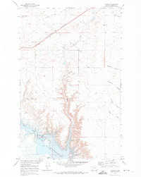
1962 Map of Mc Carters Lake SE
USGS Topo · Published 1964About this map
Kinyon Coulee cuts a deep path through the high plains of northern Montana in this 1962 survey, which documents a landscape defined by ranching and resource extraction. The area, spanning the boundary between Toole Co and Liberty Co, is marked by essential rural infrastructure including the Greenhill Sch and the north-south transit of Cavitt Road. Water management is central to life here, evidenced by the Childress Reservoir and various Wells scattered across the open terrain. A prominent industrial Pipeline traverses the landscape, illustrating the region's connection to broader energy networks. To the east, the Galata Ravine provides a natural counterpoint to the coulee systems, together forming the primary drainage pattern for this high-elevation shortgrass prairie region.
Find a feature on this map
8 named features on this map. Tap any name to fly to it.
Don’t see what you’re looking for? This feature index may not catch every label — zoom into the map to look around manually.
Map Details
Editions of this 1962 Mc Carters Lake SE Map
This is the sole edition of this map. No revisions or reprints were ever made.
Other maps of this area

1954 · Shelby
USGS Topo · 1:250,000

1958 · Shelby
USGS Topo · 1:250,000

1962 · North Lothair School
USGS Topo · 1:24,000

1962 · Hawthorne School
USGS Topo · 1:24,000

1962 · Berkholder Reservoir
USGS Topo · 1:24,000

1962 · Mc Carters Lake
USGS Topo · 1:24,000

1962 · Blair Ranch
USGS Topo · 1:24,000

1970 · Devon
USGS Topo · 1:24,000

1970 · Galata
USGS Topo · 1:24,000
1970 · Lothair
USGS Topo · 1:24,000