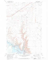
1970 Map of Lothair
USGS Topo · Published 1974About this map
Lothair sits along the northern edge of this Liberty County landscape, positioned where the Burlington Northern line tracks across the high plains. The settlement's proximity to an Old Railroad Grade indicates a shifting infrastructure in the mid-20th century. To the south, the deep, branching drainages of Eagle Creek and its many tributaries, such as Kolstad Coulee and Carter Coulee, carve through the terrain toward the massive Tiber Reservoir.
Find a feature on this map
24 named features on this map. Tap any name to fly to it.
Don’t see what you’re looking for? This feature index may not catch every label — zoom into the map to look around manually.
Map Details
Editions of this 1970 Lothair Map
This is the sole edition of this map. No revisions or reprints were ever made.
Other maps of this area

1954 · Shelby
USGS Topo · 1:250,000

1958 · Shelby
USGS Topo · 1:250,000

1962 · Tiber
USGS Topo · 1:24,000

1962 · North Lothair School
USGS Topo · 1:24,000

1962 · Mc Carters Lake SE
USGS Topo · 1:24,000

1970 · Sagebrush Coulee
USGS Topo · 1:24,000

1970 · Pondera School
USGS Topo · 1:24,000

1970 · Galata
USGS Topo · 1:24,000

1970 · Lothair SW
USGS Topo · 1:24,000
1970 · Tiber Dam
USGS Topo · 1:24,000