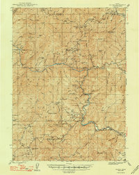
1948 Map of Galice
USGS Topo · Published 1948About this map
Gold mining operations and remote forest camps define the Siskiyou National Forest in this mid-century survey of Josephine County. The Rogue River carves a deep path through the terrain, passing landmarks such as Rainie Falls and the Grave Creek Bridge. At the river's edge, Galice and the Rand (Ranger Sta) serve as primary human outposts in a landscape dominated by timber and mineral extraction.
Find a feature on this map
115 named features on this map. Tap any name to fly to it.
Don’t see what you’re looking for? This feature index may not catch every label — zoom into the map to look around manually.
Map Details
Editions of this 1948 Galice Map
2 editions found
Other maps of this area

1904 · Riddle
USGS Topo · 1:125,000

1908 · Grants Pass
USGS Topo · 1:125,000

1917 · Kerby
USGS Topo · 1:125,000

1918 · Kerby
USGS Topo · 1:125,000

1945 · Kerby
USGS Topo · 1:125,000

1946 · Galice
USGS Topo · 1:62,500

1946 · Dutchman Butte
USGS Topo · 1:62,500

1948 · Galice
USGS Topo · 1:62,500

1948 · Dutchman Butte
USGS Topo · 1:62,500

1954 · Bone Mountain
USGS Topo · 1:62,500