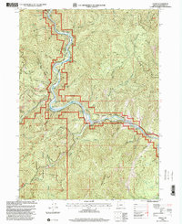
1998 Map of Galice
USGS Topo · Published 2001About this map
The Rogue National Wild and Scenic River dominates this portion of the Siskiyou Mountains, carving a deep corridor past the settlement of Galice and the Rand administrative site. This 1990s revision by the USDA Forest Service highlights a landscape transitioning from its 19th-century gold mining roots toward a modern economy of recreation and conservation. Remnants of the region's mineral wealth are visible in the numerous labeled workings, including the Almeda Mine, Golden Wedge Mine, and Black Bear Mine. While the river remains a central artery for travel via the Country Byway and river access points like Almeda County Park, the surrounding terrain is defined by steep drainages such as Taylor Creek and Stratton Creek. Notable landmarks include the dramatic Hellgate Canyon and the Rand Visitor Center, which serve as gateways to the Siskiyou National Forest.
Find a feature on this map
54 named features on this map. Tap any name to fly to it.
Don’t see what you’re looking for? This feature index may not catch every label — zoom into the map to look around manually.
Map Details
Editions of this 1998 Galice Map
This is the sole edition of this map. No revisions or reprints were ever made.
Other maps of this area

1904 · Riddle
USGS Topo · 1:125,000

1908 · Grants Pass
USGS Topo · 1:125,000

1917 · Kerby
USGS Topo · 1:125,000

1918 · Kerby
USGS Topo · 1:125,000

1945 · Kerby
USGS Topo · 1:125,000

1946 · Galice
USGS Topo · 1:62,500

1948 · Galice
USGS Topo · 1:62,500

1954 · Glendale
USGS Topo · 1:62,500

1954 · Selma
USGS Topo · 1:62,500

1954 · Grants Pass
USGS Topo · 1:62,500