Loading...
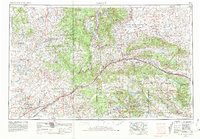
Loading map...1954 Map of Gallup
USGS Topo · Published 1981About this map
The Atchison Topeka and Santa Fe railroad serves as the primary artery through this high-desert corridor, tracing the path of the Puerco River alongside the iconic Route 66. This mid-century survey captures a landscape defined by significant cultural and administrative centers including Gallup, Window Rock, and Fort Defiance. The map highlights the vast tribal lands of the Navajo Indian Reservation and Zuni Indian Reservation, providing a detailed look at the infrastructure of the Bureau of Indian Affairs at Crownpoint (BIA).
Find a feature on this map
72 named features on this map. Tap any name to fly to it.
Don’t see what you’re looking for? This feature index may not catch every label — zoom into the map to look around manually.
Map Details
Date Portrayed1954
Date Published1981
PublisherU.S. Geological Survey
Map TypeTopographic
Scale1:250,000
Physical Dimensions31.9 x 22.1 inches
Editions of this 1954 Gallup Map
2 editions found

Historical Maps of Gallup Through Time
6 maps found


Featured Locations
- Fort Defiance Agency
- Chinle Agency, AZ
- Fort Defiance, Fort Defiance Agency
- Window Rock, Fort Defiance Agency
- Gallup, NM
Source Details
SourceU.S. Geological Survey
CopyrightPublic Domain