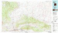
1981 Map of Gallup
USGS Topo · Published 1981About this map
The Atchison Topeka and Santa Fe railroad corridor anchors the southern edge of this McKinley County landscape, connecting the regional hub of Gallup with industrial and military sites like Gamerco and the expansive Fort Wingate Army Depot. North of the tracks, the terrain shifts into the Navajo Indian Reservation, a high-desert expanse of mesas and deep washes such as Tohatchi Wash and Coyote Wash. The map records a complex network of trading posts and post offices, including the Tohatchi Trading Post and Coyote Canyon (Brimhall PO), which served as vital community centers in this period.
Find a feature on this map
117 named features on this map. Tap any name to fly to it.
Don’t see what you’re looking for? This feature index may not catch every label — zoom into the map to look around manually.
Map Details
Editions of this 1981 Gallup Map
This is the sole edition of this map. No revisions or reprints were ever made.
Other maps of this area

1883 · Mt. Taylor
USGS Topo · 1:250,000

1886 · Wingate
USGS Topo · 1:250,000

1886 · Mt. Taylor
USGS Topo · 1:250,000

1886 · Fort Defiance
USGS Topo · 1:250,000

1889 · Largo
USGS Topo · 1:250,000

1889 · Chaco
USGS Topo · 1:250,000

1892 · Fort Defiance
USGS Topo · 1:250,000

1892 · Wingate
USGS Topo · 1:250,000

1892 · Chaco
USGS Topo · 1:250,000

1892 · Canyon De Chelly
USGS Topo · 1:250,000
Featured Places
- Gallup, NM
- Fort Defiance Agency
- Eastern Navajo Agency, NM
- Crownpoint, Eastern Navajo Agency
- Tohatchi, Fort Defiance Agency