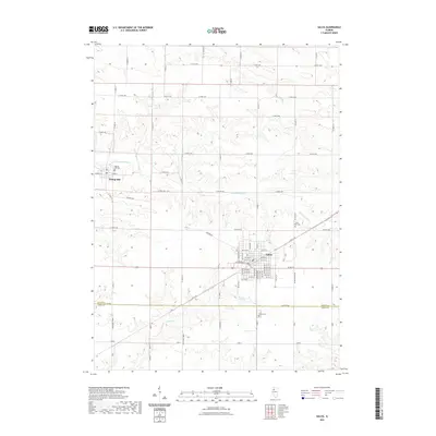
2021 Map of Galva
USGS Topo · Published 2021About this map
The agrarian landscape of Henry and Knox counties is defined here by the headwaters of the S Edwards River and its tributaries, Goose Cr and Mud Run. Centered on the town of Galva, the map reveals a meticulously organized grid of section lines and rural avenues that support the local farming economy. To the northwest, the historic settlement of Bishop Hill sits near the Bishop Hill Cem, representing a significant point of interest for those studying the area's communal heritage. The transit network is a mixture of modern numbered avenues and local named routes like Bonham Rd and Trolly Rd, illustrating how historical movement patterns have shaped the modern township. Local genealogy is further served by the presence of Saint Johns Cem and Galva Cem, which anchor the surrounding rural sections.
Find a feature on this map
42 named features on this map. Tap any name to fly to it.
Don’t see what you’re looking for? This feature index may not catch every label — zoom into the map to look around manually.
Map Details
Editions of this 2021 Galva Map
This is the sole edition of this map. No revisions or reprints were ever made.
Other maps of this area

1929 · Annawan
USGS Topo · 1:62,500

1931 · Galva
USGS Topo · 1:48,000

1932 · Annawan
USGS Topo · 1:62,500

1934 · Geneseo
USGS Topo · 1:62,500

1940 · Galva
USGS Topo · 1:62,500

1944 · Galva
USGS Topo · 1:62,500

1944 · Kewanee
USGS Topo · 1:62,500

1953 · Nekoma
USGS Topo · 1:24,000

1953 · German Corner
USGS Topo · 1:24,000
1953 · Cambridge
USGS Topo · 1:24,000