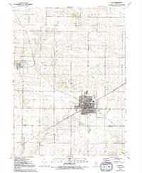
1991 Map of Galva
USGS Topo · Published 1992About this map
Bishop Hill stands as a prominent cultural landmark in the northwest corner of this Henry County survey, where the Museum and surrounding street grid reflect its origins as a communal colony. The landscape is defined by the headwaters of the South Edwards River and Goose Creek, which carve through the prairie terrain of Weller and Galva townships. The city of Galva serves as the primary population center, showing a dense development of civic life including the Library, High Sch, and multiple community spaces like Washington Park and Galva Park.
Find a feature on this map
30 named features on this map. Tap any name to fly to it.
Don’t see what you’re looking for? This feature index may not catch every label — zoom into the map to look around manually.
Map Details
Editions of this 1991 Galva Map
This is the sole edition of this map. No revisions or reprints were ever made.
Other maps of this area

1929 · Annawan
USGS Topo · 1:62,500

1931 · Galva
USGS Topo · 1:48,000

1932 · Annawan
USGS Topo · 1:62,500

1934 · Geneseo
USGS Topo · 1:62,500

1940 · Galva
USGS Topo · 1:62,500

1944 · Galva
USGS Topo · 1:62,500

1944 · Kewanee
USGS Topo · 1:62,500

1953 · Nekoma
USGS Topo · 1:24,000

1953 · German Corner
USGS Topo · 1:24,000
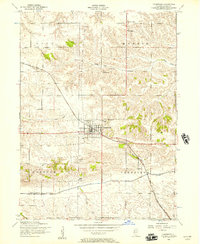
1953 · Cambridge
USGS Topo · 1:24,000