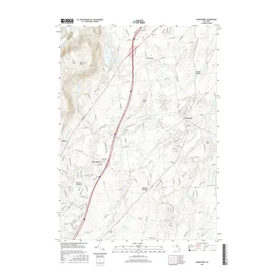
2016 Map of Gansevoort
USGS Topo · Published 2016About this map
Grant Mountain and the Palmertown Range define the western landscape of this Saratoga County region, where the terrain shifts from upland ridges to the wetlands and winding waterways of the Snook Kill drainage. Modern infrastructure, including the heavy corridor of Interstate 87, intersects a deep layer of local history preserved in the placement of small rural cemeteries. Genealogists can locate several family-named burial sites such as Dimmick Cemetery and Griswold Cemetery, alongside the distinct Old Gurn Springs and New Gurn Springs cemeteries. The settlement pattern clusters around established junctions like Gansevoort, Wilton, and Fortsville, while the CP rail line cuts through the eastern half of the map. From the recreation areas at Moreau Lake to the small-craft runway at Heber Airpark, the sheet illustrates a diverse mixture of residential growth, aviation, and preserved forest land.
Find a feature on this map
137 named features on this map. Tap any name to fly to it.
Don’t see what you’re looking for? This feature index may not catch every label — zoom into the map to look around manually.
Map Details
Editions of this 2016 Gansevoort Map
This is the sole edition of this map. No revisions or reprints were ever made.
Other maps of this area

1895 · Glens Falls
USGS Topo · 1:62,500

1897 · Glens Falls
USGS Topo · 1:62,500

1900 · Schuylerville
USGS Topo · 1:62,500

1902 · Saratoga
USGS Topo · 1:62,500

1903 · Luzerne
USGS Topo · 1:62,500
1934 · Quaker Springs
USGS Topo · 1:24,000

1934 · Saratoga Springs
USGS Topo · 1:24,000

1935 · Gansevoort
USGS Topo · 1:24,000
1935 · Schuylerville
USGS Topo · 1:24,000
1935 · Fort Miller
USGS Topo · 1:24,000