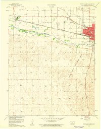
1960 Map of Garden City West
USGS Topo · Published 1961About this map
Garden City serves as the focal point of this 1960 survey, situated where the Atchison Topeka and Santa Fe railroad corridor parallels the Arkansas River. The map documents a significant era of post-war growth, showing the urban grid extending north of Kansas Ave and west toward Holcomb. Educational landmarks like Lincoln Sch, Jones Sch, and the local Jr College reflect the community's mid-century development. South of the river, the landscape transitions into the extensive Finney County State Game Refuge, characterized by sand dunes and depressions. The presence of numerous gas wells and gravel operations such as Sandpit and Gravel Pits illustrates the vital industrial and extractive activities that defined the region's economy at this time.
Find a feature on this map
23 named features on this map. Tap any name to fly to it.
Don’t see what you’re looking for? This feature index may not catch every label — zoom into the map to look around manually.
Map Details
Editions of this 1960 Garden City West Map
3 editions found
Other maps of this area

1891 · Larned
USGS Topo · 1:125,000

1896 · Garden
USGS Topo · 1:125,000

1900 · Lakin
USGS Topo · 1:125,000

1944 · Tennis
USGS Topo · 1:62,500

1955 · Dodge City
USGS Topo · 1:250,000

1955 · Scott City
USGS Topo · 1:250,000

1958 · Dodge City
USGS Topo · 1:250,000

1958 · Scott City
USGS Topo · 1:250,000

1959 · Dodge City
USGS Topo · 1:250,000

1960 · Garden City East
USGS Topo · 1:24,000