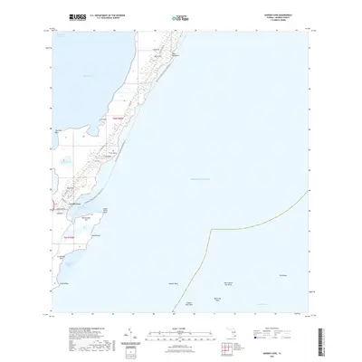
2021 Map of Garden Cove
USGS Topo · Published 2021About this map
Garden Cove and the northern reaches of Key Largo define this coastal landscape, where the terrestrial mangroves and hammock ridges of the Florida Keys meet the expanse of the Atlantic Ocean. The shoreline is heavily articulated by features like Cove Point, Point Mary, and the sheltered waters of Barnes Sound. Inland, the geography is marked by subtle elevations like Basin Hills and isolated water bodies such as Lake Simmons. The maritime character is further emphasized by a network of reefs and shoals, including Higdons Reef and The Elbow, which frame the deep-water Hawk Channel. This coastal survey documents the intersection of modern transit routes, such as the Intracoastal Waterway and Co Rd 905, with the intricate natural boundary of the southern peninsula.
Find a feature on this map
36 named features on this map. Tap any name to fly to it.
Don’t see what you’re looking for? This feature index may not catch every label — zoom into the map to look around manually.
Map Details
Editions of this 2021 Garden Cove Map
This is the sole edition of this map. No revisions or reprints were ever made.
Other maps of this area

1947 · Garden Cove
USGS Topo · 1:24,000

1947 · Rock Harbor
USGS Topo · 1:24,000

1947 · Blackwater Sound
USGS Topo · 1:24,000

1949 · Blackwater Sound
USGS Topo · 1:24,000

1949 · Rock Harbor
USGS Topo · 1:24,000

1949 · Garden Cove
USGS Topo · 1:24,000

1949 · Card Sound
USGS Topo · 1:24,000

1949 · Pacific Reef
USGS Topo · 1:24,000

1950 · Glades
USGS Topo · 1:24,000

1956 · Card Sound
USGS Topo · 1:24,000