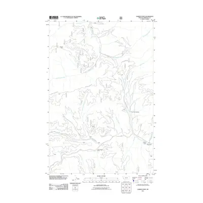
2011 Map of Garden Point
USGS Topo · Published 2011About this map
Garden Point rises above a complex network of waterways in Missoula County, where the Bitterroot Range topography dictates the flow of numerous drainages including Petty Creek and the West Fork Lolo Creek. The landscape is defined by its early travel and passage history, evidenced by the presence of Chief Joseph Gulch and the Lewis and Clark Campground. These names reflect the historical transit through these mountain corridors. Modern access follows historical footprints along routes such as Petty Creek Rd and Grave Creek Rd, which weave through the valleys toward Grave Creek Meadow. The hydrology is remarkably dense, with tributaries like Cloudburst Creek, Hungry Creek, and Cedar Run Creek carving into the terrain. This survey provides a clear view of the wilderness management and recreational infrastructure in place during the early 21st century.
Find a feature on this map
29 named features on this map. Tap any name to fly to it.
Don’t see what you’re looking for? This feature index may not catch every label — zoom into the map to look around manually.
Map Details
Editions of this 2011 Garden Point Map
This is the sole edition of this map. No revisions or reprints were ever made.
Other maps of this area

1911 · Lolo
USGS Topo · 1:250,000

1912 · Missoula
USGS Topo · 1:125,000

1913 · Lolo
USGS Topo · 1:250,000

1956 · Hamilton
USGS Topo · 1:250,000

1959 · Hamilton
USGS Topo · 1:250,000

1960 · Hamilton
USGS Topo · 1:250,000

1964 · Hamilton
USGS Topo · 1:250,000
1964 · Diamond Point
USGS Topo · 1:24,000

1964 · Lolo Hot Springs
USGS Topo · 1:24,000

1964 · Garden Point
USGS Topo · 1:24,000