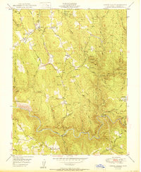
1950 Map of Garden Valley
USGS Topo · Published 1950About this map
Eldorado National Forest dominates the eastern ridges of this 1950 survey, where the deep canyons of the South Fork American River define the southern border. The landscape is a legacy of California's gold country, marked by numerous industrial and community landmarks including the Taylor Mine, Nancy Lee Mine, and Black Oak Mine. The settlement of Garden Valley serves as a northern hub, connected to outlying locales like Kelsey and the riverside Chili Bar.
Find a feature on this map
56 named features on this map. Tap any name to fly to it.
Don’t see what you’re looking for? This feature index may not catch every label — zoom into the map to look around manually.
Map Details
Editions of this 1950 Garden Valley Map
This is the sole edition of this map. No revisions or reprints were ever made.
Other maps of this area

1891 · Placerville
USGS Topo · 1:125,000

1892 · Placerville
USGS Topo · 1:125,000

1893 · Placerville
USGS Topo · 1:125,000

1947 · Sacramento
USGS Topo · 1:250,000

1948 · Sacramento
USGS Topo · 1:250,000

1949 · Georgetown
USGS Topo · 1:62,500

1949 · Placerville
USGS Topo · 1:62,500
1949 · Georgetown
USGS Topo · 1:24,000

1949 · Placerville
USGS Topo · 1:24,000
1949 · Coloma
USGS Topo · 1:24,000