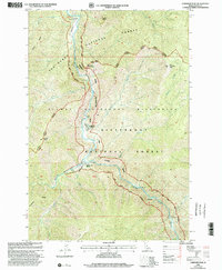
1998 Map of Gardiner Peak
USGS Topo · Published 2002About this map
Selway River and the Middle Fork Clearwater River define this wilderness corridor within the Nez Perce National Forest. The map documents a remote river-dependent landscape where access is limited to a few specific sites such as the Shearer Guard Station and established riverfront holdings like the North Star Ranch and Running Creek Ranch. Numerous land features like Elevator Mountain, Archer Point, and the prominent Gardiner Peak overlook the narrow canyon floors.
Find a feature on this map
34 named features on this map. Tap any name to fly to it.
Don’t see what you’re looking for? This feature index may not catch every label — zoom into the map to look around manually.
Map Details
Editions of this 1998 Gardiner Peak Map
This is the sole edition of this map. No revisions or reprints were ever made.
Other maps of this area

1911 · Lolo
USGS Topo · 1:250,000

1913 · Lolo
USGS Topo · 1:250,000

1956 · Elk City
USGS Topo · 1:250,000

1956 · Hamilton
USGS Topo · 1:250,000

1959 · Hamilton
USGS Topo · 1:250,000

1960 · Elk City
USGS Topo · 1:250,000

1960 · Hamilton
USGS Topo · 1:250,000

1964 · Hamilton
USGS Topo · 1:250,000

1966 · Spot Mountain
USGS Topo · 1:24,000

1966 · Twin Butte
USGS Topo · 1:24,000