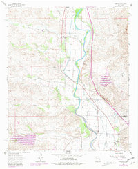
1961 Map of Garfield
USGS Topo · Published 1981About this map
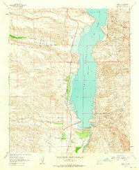
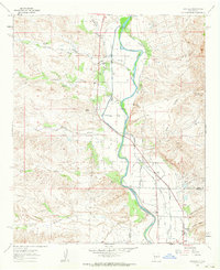
The Rio Grande defines this corridor of the Rio Grande Valley during the early 1960s, showing a complex irrigation system vital to the region's agricultural life. Engineered features like the Percha Dam, Arrey Siphon, and the Garfield Flume demonstrate the intensive water management required to sustain settlements like Arrey, Derry, and Garfield. Local social anchors are visible throughout, including the San Jose Ch, the Church of God, and the San Isidro Sch, providing valuable points of interest for genealogists and local historians. Beyond the cultivated valley floor, the terrain transitions into arid drainages such as Arroyo Montoya and Berrenda Creek, where the map records numerous prospects and small-scale mining activity. The presence of the Sierra Co Dona Ana Co line highlights the jurisdictional boundary crossing the river, while a network of jeep trails and a radio tower mark the mid-century infrastructure of southern New Mexico.
Find a feature on this map
49 named features on this map. Tap any name to fly to it.
Don’t see what you’re looking for? This feature index may not catch every label — zoom into the map to look around manually.
Map Details
Editions of this 1961 Garfield Map
2 editions found
Other maps of this area

1955 · Las Cruces
USGS Topo · 1:250,000

1958 · Las Cruces
USGS Topo · 1:250,000
1958 · Arroyo Cuervo
USGS Topo · 1:24,000
1959 · Hatch
USGS Topo · 1:24,000
1959 · Upham
USGS Topo · 1:62,500

1961 · Skute Stone Arroyo
USGS Topo · 1:24,000
1961 · Caballo
USGS Topo · 1:24,000
1961 · Nutt
USGS Topo · 1:62,500
1961 · Clark Spring Canyon
USGS Topo · 1:24,000
1961 · Garfield
USGS Topo · 1:24,000