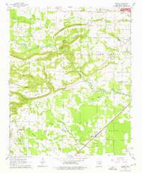
1963 Map of Garner
USGS Topo · Published 1976About this map
Garner and Higginson anchor the southeastern portion of this landscape, situated along the Missouri Pacific railroad. The terrain is defined by a complex network of ridges and drainages, most notably Honey Hill Ridge and Peanut Ridge, which divide the lowland Des Arc Bayou from the surrounding highlands. This 1963 survey captures the rural character of White County, documenting numerous local landmarks that served the surrounding farmsteads, including Honey Hill Ch, Sixteenth Section Ch, and Copperas Springs Ch. Evidence of earlier transport is visible in the Old Railroad Grade north of the Searcy Country Club. To the north, the southern edge of Searcy begins to encroach on the rural landscape near Gin Creek, while family history is preserved at sites like Gum Springs Cem and Weir Cem.
Find a feature on this map
47 named features on this map. Tap any name to fly to it.
Don’t see what you’re looking for? This feature index may not catch every label — zoom into the map to look around manually.
Map Details
Editions of this 1963 Garner Map
3 editions found
Other maps of this area

1932 · Kensett
USGS Topo · 1:62,500

1935 · Kensett
USGS Topo · 1:62,500

1935 · Bald Knob
USGS Topo · 1:62,500

1953 · Memphis
USGS Topo · 1:250,000

1956 · Memphis
USGS Topo · 1:250,000

1962 · Letona
USGS Topo · 1:24,000

1963 · Garner
USGS Topo · 1:24,000

1963 · Floyd
USGS Topo · 1:24,000

1963 · Sidon
USGS Topo · 1:24,000
1963 · Beebe
USGS Topo · 1:24,000