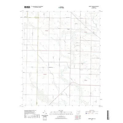
2020 Map of Garrett Grove
USGS Topo · Published 2020About this map
Garrett Grove and the nearby community of Hopper anchor this rural landscape in eastern Arkansas, where the borders of Lee, St. Francis, and Monroe Counties converge. The terrain is defined by a complex network of waterways, including the winding course of Big Creek and Little Hog Tusk Cr, alongside standing water features such as Whistling Lake and Walnut Lake. The distribution of cemeteries across the township lines, such as Saint Paul Cem, Prospect Cem, and Long Cane Cem, suggests a long-established pattern of rural settlement. A dense grid of county roads, including Mount Jordan Rd and Lee Road 902, provides access through the low-lying terrain, linking family homesteads and local landmarks within the T3N and T2N survey ranges.
Find a feature on this map
59 named features on this map. Tap any name to fly to it.
Don’t see what you’re looking for? This feature index may not catch every label — zoom into the map to look around manually.
Map Details
Editions of this 2020 Garrett Grove Map
This is the sole edition of this map. No revisions or reprints were ever made.
Other maps of this area

1940 · Marvell
USGS Topo · 1:62,500

1940 · Holly Grove
USGS Topo · 1:62,500

1940 · Brinkley
USGS Topo · 1:62,500

1940 · Marianna
USGS Topo · 1:62,500

1948 · Helena
USGS Topo · 1:250,000

1950 · Helena
USGS Topo · 1:250,000

1955 · Helena
USGS Topo · 1:250,000

1956 · Marvell
USGS Topo · 1:62,500
1957 · Marianna
USGS Topo · 1:62,500

1957 · Holly Grove
USGS Topo · 1:62,500