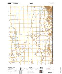
2020 Map of Garrison Lake
USGS Topo · Published 2020About this map
Catlow Valley dominates this high desert landscape in Harney County, where water management is central to the survival of the local cattle industry. The presence of Stockwater Ditch and several named ephemeral water bodies, including Garrison Lake, West Field Lake, and Sixmile Lake, underscores the seasonal nature of the region's hydrology. These basins and reservoirs, such as Threemile Reservoir, provide critical collection points for runoff from the surrounding drainages of Skull Cr and Threemile Cr. The landscape is largely defined by its township and range grid, with Catlow Valley Rd serving as the primary corridor through this sparsely populated basin. This 2020 update reflects a territory where traditional ranching infrastructure, such as ditching and stock water sources, remains the primary human footprint on the land.
Find a feature on this map
15 named features on this map. Tap any name to fly to it.
Don’t see what you’re looking for? This feature index may not catch every label — zoom into the map to look around manually.
Map Details
Editions of this 2020 Garrison Lake Map
This is the sole edition of this map. No revisions or reprints were ever made.
Other maps of this area

1955 · Adel
USGS Topo · 1:250,000

1957 · Adel
USGS Topo · 1:250,000

1958 · Adel
USGS Topo · 1:250,000

1962 · Adel
USGS Topo · 1:250,000

1968 · Roaring Springs SE
USGS Topo · 1:24,000

1971 · Square Mountain
USGS Topo · 1:24,000

1971 · Fields Basin
USGS Topo · 1:24,000

1971 · Blitzen
USGS Topo · 1:24,000

1971 · Coyote Gap SE
USGS Topo · 1:24,000

1971 · Garrison Lake
USGS Topo · 1:24,000