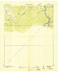
1936 Map of Gatlinburg
USGS Topo · Published 1936About this map
Great Smoky Mountains National Park dominates the lower half of this mid-1930s landscape, just as the park was entering its early years of federal development. To the north, the small mountain settlement of Gatlinburg is shown at an elevation of 1,292 feet, centered on the West Fork Little Pigeon River. The map reveals a network of mountain roads and paths, including Tenn State Hwy No 71 and the high-elevation Gibson Trail. Rural community life is anchored by landmarks like Covemont Sch and the Husky Grove Ch, while family-named terrain like Clabo Ridge and Ownby Hollow speaks to the deep-rooted genealogy of Sevier County. This survey, compiled from aerial photographs by the Tennessee Valley Authority and USGS, serves as a record of the area before the full expansion of modern tourism infrastructure.
Find a feature on this map
38 named features on this map. Tap any name to fly to it.
Don’t see what you’re looking for? This feature index may not catch every label — zoom into the map to look around manually.
Map Details
Editions of this 1936 Gatlinburg Map
This is the sole edition of this map. No revisions or reprints were ever made.
Other maps of this area

1886 · Knoxville
USGS Topo · 1:125,000

1892 · Knoxville
USGS Topo · 1:125,000

1893 · Mt Guyot
USGS Topo · 1:125,000

1894 · Knoxville
USGS Topo · 1:125,000

1895 · Knoxville
USGS Topo · 1:125,000

1901 · Knoxville
USGS Topo · 1:125,000

1912 · Mt Guyot
USGS Topo · 1:125,000

1935 · English Mountain
USGS Topo · 1:48,000

1935 · Walden Creek
USGS Topo · 1:24,000

1935 · Richardson Cove
USGS Topo · 1:24,000