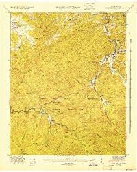
1943 Map of Gatlinburg
USGS Topo · Published 1943About this map
Gatlinburg serves as a developing gateway to the Great Smoky Mountains National Park during the early 1940s, a period marked by the transition from rural mountain settlements to a structured park landscape. The map details smaller communities like Starkeytown and Elkmont, alongside several specialized installations such as CCC Camp 1468 NP-2 and Camp LeConte. Cultural and community anchors are well-preserved in the record, including the Valley View Ch and Covemont Sch within Wear Cove, and local family landmarks like Crowson Cem and the Jim Carr Mill. The topography is dominated by the massive Cove Mountain and the Chinquapin Ridge, with numerous gaps and hollows reflecting a deep history of local naming. A proposed boundary line signifies the ongoing expansion and formalization of the national park lands, while the Holston Assembly Grounds and Millsap Picnic Grds indicate the rising importance of recreation and seasonal residency in the region.
Find a feature on this map
117 named features on this map. Tap any name to fly to it.
Don’t see what you’re looking for? This feature index may not catch every label — zoom into the map to look around manually.
Map Details
Editions of this 1943 Gatlinburg Map
This is the sole edition of this map. No revisions or reprints were ever made.
Other maps of this area

1886 · Knoxville
USGS Topo · 1:125,000

1892 · Knoxville
USGS Topo · 1:125,000

1893 · Mt Guyot
USGS Topo · 1:125,000

1894 · Knoxville
USGS Topo · 1:125,000

1895 · Knoxville
USGS Topo · 1:125,000

1901 · Knoxville
USGS Topo · 1:125,000

1912 · Mt Guyot
USGS Topo · 1:125,000

1935 · English Mountain
USGS Topo · 1:48,000

1935 · Walden Creek
USGS Topo · 1:24,000

1935 · Richardson Cove
USGS Topo · 1:24,000