
2010 Map of Gatzke
USGS Topo · Published 2010About this map
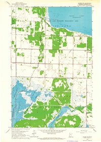
The unincorporated community of Gatzke serves as the focal point for this rural Marshall County landscape, where the agricultural grid is defined by the winding course of the Moose River. In the northwest, the map documents the eastern reaches of Thief Lake, a significant local water body that influences the surrounding drainage patterns and road layouts. The map reveals the long-standing community infrastructure of the early 21st century, including essential sites for genealogical research such as Moose River Cemetery and Lundsted Cemetery. Local transportation and utility are reflected in the inclusion of Hagens Airport and Paul Field, which sit alongside a network of county highways including County Hwy 131 and County Hwy 132. The landscape remains largely defined by its hydrology, with Webster Creek and various river bends cutting through the organized sections of the township.
Find a feature on this map
21 named features on this map. Tap any name to fly to it.
Don’t see what you’re looking for? This feature index may not catch every label — zoom into the map to look around manually.
Map Details
Editions of this 2010 Gatzke Map
This is the sole edition of this map. No revisions or reprints were ever made.
Other maps of this area

1918 · Rollis
USGS Topo · 1:62,500

1918 · Pencer
USGS Topo · 1:62,500

1918 · Garland
USGS Topo · 1:62,500

1919 · Liner
USGS Topo · 1:62,500

1943 · Rollis
USGS Topo · 1:62,500

1954 · Roseau
USGS Topo · 1:250,000

1957 · Roseau
USGS Topo · 1:250,000

1958 · Roseau
USGS Topo · 1:250,000
1962 · Gatzke NW
USGS Topo · 1:24,000

1962 · Gatzke SE
USGS Topo · 1:24,000