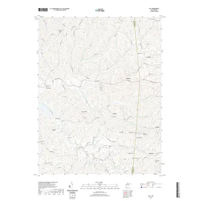
2019 Map of Gay
USGS Topo · Published 2019About this map
Gay sits at the junction of Gay Rd and Gay Allentown Rd, serving as a central point in this rural landscape where the Jackson Co and Roane Co border winds across ridges and hollows. The area is defined by its numerous family and community burial grounds, such as Baptist Grove Cem, Litton Cem, and Camelite Cem, which provide essential touchstones for genealogical research in this part of West Virginia. The terrain is marked by sharp elevations like Buckeye Knob and Monroe Knob, with narrow valleys carved by waterways including Little Cr, Elk Fork, and the Right Fork Frozencamp Cr. Small settlements like Hereford, Marshall, and Allentown are connected by a network of secondary routes such as Co Rte 28 and Co Rte 22, reflecting a long-standing pattern of ridge-top and valley-floor habitation that persists even into the modern era.
Find a feature on this map
119 named features on this map. Tap any name to fly to it.
Don’t see what you’re looking for? This feature index may not catch every label — zoom into the map to look around manually.
Map Details
Editions of this 2019 Gay Map
This is the sole edition of this map. No revisions or reprints were ever made.
Other maps of this area

1906 · Kenna
USGS Topo · 1:62,500

1906 · Walton
USGS Topo · 1:62,500

1907 · Kenna
USGS Topo · 1:62,500

1907 · Spencer
USGS Topo · 1:62,500

1907 · Walton
USGS Topo · 1:62,500

1907 · Ripley
USGS Topo · 1:62,500

1926 · Ripley
USGS Topo · 1:62,500

1928 · Spencer
USGS Topo · 1:62,500

1928 · Ripley
USGS Topo · 1:62,500

1954 · Charleston
USGS Topo · 1:250,000