
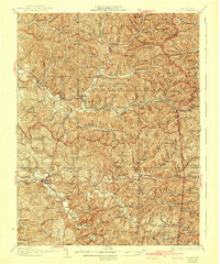
1928 Map of Ripley
USGS Topo · Published 1928About this map
Ripley serves as the hub for this survey of rural Jackson County, situated where the Baltimore and Ohio Railroad meets the winding course of Mill Creek. The landscape is a dense network of ridges and hollows, characterized by numerous country schools and churches that reflect the dispersed settlement pattern of the 1920s. Small communities like Sandyville, Silverton, and Odaville are linked by the Spencer and Ravenswood Road, while dozens of family and community landmarks such as Morning Star Sch and Hargreave Knob mark the terrain. The map captures the area just after cultural revisions were made in 1926, showing the precise locations of rural infrastructure before modern consolidation. From the Wirt County border to the southwest corners near Fairplain, the documentation of every Mill and local Cem offers a detailed view of West Virginia's interior hill country.
Find a feature on this map
82 named features on this map. Tap any name to fly to it.
Don’t see what you’re looking for? This feature index may not catch every label — zoom into the map to look around manually.
Map Details
Editions of this 1928 Ripley Map
2 editions found
Other maps of this area

1906 · Elizabeth
USGS Topo · 1:62,500

1906 · Belleville
USGS Topo · 1:62,500

1906 · Kenna
USGS Topo · 1:62,500

1906 · Winfield
USGS Topo · 1:62,500

1906 · Walton
USGS Topo · 1:62,500

1907 · Kenna
USGS Topo · 1:62,500

1907 · Spencer
USGS Topo · 1:62,500

1907 · Walton
USGS Topo · 1:62,500

1907 · Keno
USGS Topo · 1:62,500

1907 · Ripley
USGS Topo · 1:62,500