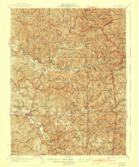
1928 Map of Ripley
USGS Topo · Published 1942About this map
Ripley serves as the focal point of this 1920s-era landscape, where the Baltimore and Ohio RR cuts a path through the winding valleys of Sandy Creek and Mill Creek. The settlement pattern revealed here is one of dense, localized rural communities, each anchored by its own named schoolhouse or church. From the Morning Star Sch in the north to the Valley Bell Sch along the Middle Fork, these small institutions define the social geography of the era. The terrain is characterized by a series of prominent knobs and hills, such as Balis Knob and Hargreave Knob, which separate the various runs and forks. This survey, revised just before the close of the decade, captures a transitional moment for small villages like Sandyville, Silverton, and Meadowdale as the local rail and river network continued to shape the economy of Jackson and Roane Counties.
Find a feature on this map
111 named features on this map. Tap any name to fly to it.
Don’t see what you’re looking for? This feature index may not catch every label — zoom into the map to look around manually.
Map Details
Editions of this 1928 Ripley Map
2 editions found

Other maps of this area

1906 · Elizabeth
USGS Topo · 1:62,500

1906 · Belleville
USGS Topo · 1:62,500

1906 · Kenna
USGS Topo · 1:62,500

1906 · Winfield
USGS Topo · 1:62,500

1906 · Walton
USGS Topo · 1:62,500

1907 · Kenna
USGS Topo · 1:62,500

1907 · Spencer
USGS Topo · 1:62,500

1907 · Walton
USGS Topo · 1:62,500

1907 · Keno
USGS Topo · 1:62,500

1907 · Ripley
USGS Topo · 1:62,500