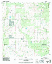
1994 Map of Gaytine
USGS Topo · Published 1996About this map
Marsh Bayou and Indian Bayou wind through the heart of this southwest Louisiana landscape, where the confluence of three parishes—Beauregard, Allen, and Calcasieu—shapes the local geography. The settlement at Gaytine sits central to a network of rural roads and pipelines, while Turps and Gillis serve as small inland hubs to the south. This 1990s revision reflects a landscape transition between forest and waterway, notably preserved in the drainage patterns of Boggy Creek and Hickory Branch. The presence of the Habeth Landing Strip and a prominent Comm Tower indicates how the mid-century rural economy integrated modern communications and transport into the timber-rich parish boundaries.
Find a feature on this map
17 named features on this map. Tap any name to fly to it.
Don’t see what you’re looking for? This feature index may not catch every label — zoom into the map to look around manually.
Map Details
Editions of this 1994 Gaytine Map
This is the sole edition of this map. No revisions or reprints were ever made.
Other maps of this area

1935 · Buhler
USGS Topo · 1:31,680

1935 · Moss Bluff
USGS Topo · 1:31,680

1935 · Gordon
USGS Topo · 1:31,680

1935 · Gaytine
USGS Topo · 1:31,680

1935 · Longville
USGS Topo · 1:31,680

1947 · Gaytine
USGS Topo · 1:31,680

1947 · Moss Bluff
USGS Topo · 1:31,680

1947 · Hecker
USGS Topo · 1:31,680

1947 · Kernan
USGS Topo · 1:31,680

1947 · Reeves
USGS Topo · 1:31,680